
September 30 history blog post: One of a series of short essays to provide the cultural, political and geographical context for the 1766 travelers.
Salome Meurer’s journal is the main source for determining the route taken by the 1766 party from Bethlehem to Bethabara. The journal provides excellent detail for the Pennsylvania portion of the route, and Salome names the towns they passed through in Maryland and North Carolina, but we are given scant detail for the 12 days they spent in Virginia. As Eric Elliott, former archivist at the Moravian Archives pointed out, the Pennsylvania portion of the trip was a “farewell tour” of sorts, visiting other Moravian settlers and familiar communities where they had many friends and family, so there was much for Salome to say. However, the route through Virginia consisted of forestland and river crossings, which all may have looked unremarkable to a 16-year-old.
Salome specifically mentions passing through Leesburg, Virginia, but then does not mention another town until Corbintown (Hillsborough, North Carolina). That left the planning committee for The Journey From Bethlehem to Salem with a challenge: was there a way to determine the exact route through Virginia?
We consulted many sources. Our internet search led us to an intriguing possibility: the “Upper Road” through Virginia. Numerous websites showed this route, listing the modern-day counties it traversed: Spotsylvania, Louisa, Goochland, Powhatan, Amelia, Nottoway, Lunenburg, and Mecklenburg. However, when we investigated more deeply, we discovered that all these websites were using the same description verbatim, as well as the same map. We traced the verbiage back to its original source, which was Map Guide to American Migration Routes, 1735-1815, by William Dollarhide. Dollarhide’s book, however, did not lead us to a primary reference source for Upper Road, and we were unable to contact Dollarhide.
We also saw references to “Carolina Road,” a north-south colonial route through Virginia that began in Frederick, Maryland, and followed Indian trading paths to the Roanoke River on the border of North Carolina. But we could not find a primary reference source for this road.
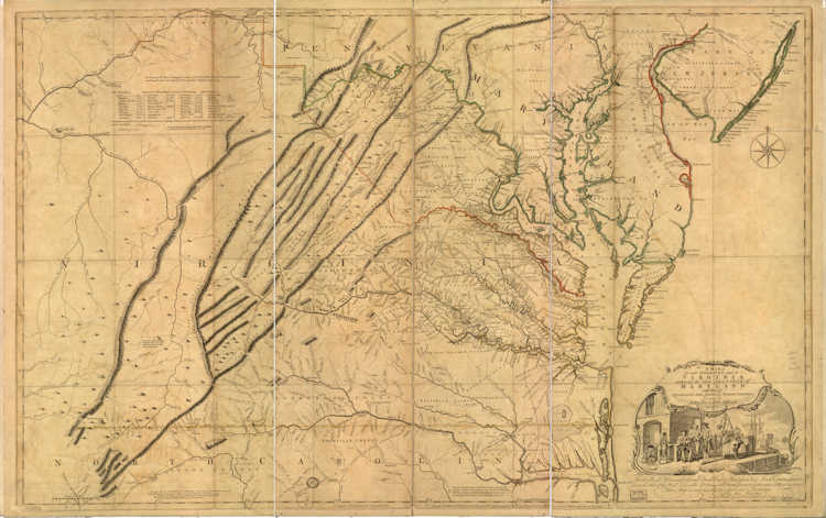
We consulted many maps, including a 1755 map by Peter Jefferson, a 1787 map by Thomas Jefferson, a 1755 map of the middle British colonies, and a 1770 map of Virginia. None of these showed a north-south route as described by Dollarhide or any route that extended from Frederick, Maryland, through Virginia, although several of these maps showed the Great Wagon Road through the Shenandoah Valley — west of Dollarhide’s Upper Road and west of today’s U.S. 15.
We know that the first party that traveled from Bethlehem to North Carolina to settle Bethabara (October 1753) took the Great Wagon Road. Records of the Moravians in North Carolina, Vol. 1: 1752-1771, edited by Adelaide Fries, provides an abridged transcription of a diary of the journey. The diary specifically mentions passing through Winchester and Staunton, Virginia and describes very hilly terrain that was difficult and dangerous for the horses hauling the wagon. Tantalizingly, Fries calls the route the Upper Road, although it clearly is not the same Upper Road referenced by Dollarhide. In fact, Fries lists the counties traversed in a footnote: Frederick, Shenandoah, Rockingham, Augusta, Rockbridge, Botetourt, Roanoke, Franklin and Patrick. The travelers entered North Carolina via Stokes County, according to Fries, which is considerably west of Hillsborough, the first North Carolina town mentioned by Salome Meurer.
The term “Upper Road” may have been a convention employed only by Fries to describe the Great Wagon Road. In The Road to Salem, Fries refers to an April 1759 journey undertaken by 12 Moravians from Bethlehem to Bethabara as traveling “the lower road by Frederick, Maryland and Orange Courthouse, Virginia.” The primary reason for taking this route, rather than the Great Wagon Road, was safety. They encountered no Indians, and the road was in better condition with fewer elevation changes than the Great Wagon Road. We can surmise that the 1766 party may have taken the same route. Salome’s journal mentions Frederick, Maryland but it does not mention Orange Courthouse. Salome does mention two courthouses: Normen (?) Courthouse on October 17 and an unnamed court house on October 18.
Daniel Crews and Richard Starbuck of the Moravian Archives provide an additional clue in With Courage for the Future: The Story of the Moravian Church, Southern Province. They note that Dudley Shearburn, who recreated the journey from Bethlehem to Bethabara in 1981, “took the ‘upper road’ following the Great Wagon road along the Shenandoah Valley along what is now U.S. 11. The Single Sisters and Older Girls (1766) took the ‘lower road’ to the east of the Appalachian Mountains, generally along present-day U.S. 15.”
There may be other journals or primary sources in the Moravian Archives that would provide precise detail on the route the 1766 party took, but if they exist, they have not been translated into English. As a result of having no definitive, specific evidence otherwise, the planning committee for the Journey to Salem elected to retrace the steps of the 1766 party by following U.S. 15 through Virginia, as described by Crews and Starbuck.
Virginia S. Hart A’75
Resources:
Aaron S. Fogleman, “Women on the Trail in Colonial America: A Travel Journal of German Moravians Migrating from Pennsylvania to North Carolina in 1766,” Pennsylvania History, Vol. 61, No. 2, April 1994 (includes a translation of Salome Meurer’s journal)
William Dollarhide, Map Guide to American Migration Routes, 1735-1815
Adelaide Fries, Records of the Moravians in North Carolina Volume I, 1752-1771
Adelaide Fries, The Road to Salem
C. Daniel Crews and Richard W. Starbuck, With Courage for the Future: The Story of the Moravian Church, Southern Province
Washington Post, 4/22/2001, “Colonial Travelers Found Road Rough Going”
Eugene Scheel, “The Carolina Road”
1755 map by Peter Jefferson
1787 map by Thomas Jefferson
Douglas Waitley, Roads of Destiny: The Trails That Shaped A Nation
1755 map of the middle British colonies
1770 map of Virginia
1761 map of Virginia